Here is the latest:
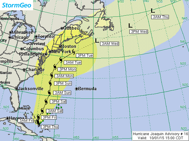
Current Location: 23N / 74.3W
Geographic Reference: 60 miles southeast of San Salvador Island, Bahamas
Movement: West at 3 mph
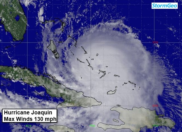
Maximum Sustained Winds:130 mph gusting to 155 mph
Current Radius of Tropical Storm Force Winds: 140 miles
Peak Forecast Radius of Tropical Storm Force Winds:310 miles as it passes south of Newfoundland as an extratropical storm.
Current Hurricane Severity Index: 23 out of a possible 50 points (8 size, 15 intensity)
Peak Forecast Hurricane Severity Index: 26 out of a possible 50 points (13 size, 13 intensity)
Organizational Trend: Steady
Forecast Confidence: Low
Changes from our Previous Advisory
Over the past 12 hours, data from a G-IV recon plane sampling the atmosphere surrounding Joaquin along with 4 per day balloon launches all up and down the East U.S. Coast have been ingested by the latest computer models. The result is a decided shift to the east, not just with the single deterministic runs, but with most of the ensemble members for each of the main computer models. While the new ensemble plot is not available for inclusion in this advisory, it will likely indicate a significantly decreased threat of a hurricane landfall along the East U.S. Coast this weekend.
Because of this trend, we have adjusted our track about 150 miles to the east of our previous track, and even that is not as far east as the latest model guidance is indicating. This track shift means that the East U.S. Coast may only be grazed by Joaquin's tropical storm force winds on Sunday and Monday. In addition, all of Joaquin's heavier squalls should remain east of the U.S.
Finally, we have increased Joaquin's 39 mph wind radii considerably beyond 96 hours when the storm will be transitioning to an extratropical storm offshore Nova Scotia and Newfoundland.
Our Forecast
Our forecast takes the center of what is predicted to be category 2 Hurricane Joaquin about 170 miles east of Cape Hatteras late
Sunday night or early
Monday morning. By early
Tuesday morning, we have the center of category 1 Hurricane Joaquin passing about 225 miles east of the New Jersey coast. By
Tuesday afternoon/evening, Tropical Storm Joaquin is forecast to pass about 190 miles east of Cape Cod. At that time, Joaquin should have begun the transition to a larger extratropical storm, which is what we expect Joaquin to become as it passes south and east of Nova Scotia and Newfoundland
next Wednesday.
Reports from a recon plane indicate that Joaquin may have reached its peak intensity earlier this morning. This could be partially due to the upwelling of cooler water beneath the slow-moving hurricane. Some slow weakening is expected
tomorrow as Joaquin moves northward over slightly cooler water. More rapid weakening is likely on Saturday and Sunday as Joaquin begins to accelerate to the north and northeast.
Expected Impacts Onshore
Bahamas (Nassau and Great Abaco Island): Low-end tropical storm force winds this evening
through Friday morning may cause minor damage and power outages. Joaquin's heavier squalls should pass east of these islands.
East U.S. Coast: Tropical storm-force winds may graze the coast on Sunday and Monday, producing scattered power outages. Joaquin's heavy rain should remain offshore, though the area will still receive heavy rain
through Saturday associated with a frontal system and slow-moving upper-level storm system. Tides along the East Coast will run 2-3 feet above normal
Saturday through Monday due to large waves moving ashore.
Our next advisory will be issued by
10PM EDT.
Meteorologist: Chris Hebert
Forecast Confidence: Low Hurricane Severity Index
Fcst Hour Valid Lat. Lon. Max Sustained Winds Max Gusts Category Size Intensity Total
0 3PM CDT Thu Oct 01 23.00N 74.30W 130 mph 155 mph Category 4 8 15 23
12 3AM CDT Fri Oct 02 23.50N 74.50W 130 mph 165 mph Category 4 11 15 26
24 3PM CDT Fri Oct 02 24.50N 74.50W 125 mph 150 mph Category 3 13 13 26
36 3AM CDT Sat Oct 03 26.10N 73.70W 120 mph 145 mph Category 3 14 12 26
48 3PM CDT Sat Oct 03 28.50N 73.00W 115 mph 140 mph Category 3 14 11 25
60 3AM CDT Sun Oct 04 30.70N 72.40W 110 mph 130 mph Category 2 14 10 24
72 3PM CDT Sun Oct 04 33.00N 72.50W 105 mph 120 mph Category 2 11 9 20
84 3AM CDT Mon Oct 05 35.00N 72.40W 90 mph 110 mph Category 1 8 7 15
96 3PM CDT Mon Oct 05 37.20N 71.80W 85 mph 105 mph Category 1 7 6 13
108 3AM CDT Tue Oct 06 39.10N 70.20W 80 mph 100 mph Category 1 7 5 12
120 3PM CDT Tue Oct 06 41.30N 66.40W 70 mph 80 mph Tropical Storm 5 4 9
132 3AM CDT Wed Oct 07 44.00N 59.00W 60 mph 70 mph Extratropical Storm 4 3 7
144 3PM CDT Wed Oct 07 47.00N 47.00W 50 mph 65 mph Extratropical Storm 3 2 5
156 3AM CDT Thu Oct 08 49.50N 38.00W 45 mph 60 mph Extratropical Storm 3 2 5
*Note: There is a 75% chance this storm's center will track within the yellow "cone of uncertainty" depicted above. The width of this cone is based on average track errors over the last 5 years. Hurricane-force winds, a significant storm surge and heavy rainfall can often extend outside this uncertainty cone.
© 2015 StormGeo, Inc. All rights reserved.
tropicswatch@stormgeo.com