

tfrere
Thomas McNulty
If you or your boat are on the gulf coast then you should be aware of this potentially dangerous hurricane.
Disturbance 26 Advisory 21
Valid: 09:00 AM CDT Wednesday August 24, 2016
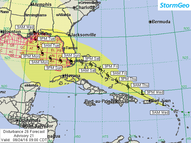
Current Position: 17.4N / 63.6W Geographical Reference: 150 NM ESE of San Juan Max Sustained Winds: 30 kts gusting 40 kts Movement: West-northwest at 17 kts Current Hurricane Severity Index: 1 (0 size / 1 intensity) Max Predicted Hurricane Severity Index: 23 (14 size / 9 intensity) Max Predicted Radius of Tropical Storm-Force Winds: 140 NM Organizational Trend: Slowly getting better organized Development Chances Over the Next 7 Days: 90 percent Forecast Confidence: Below Average
Changes From Our Previous Advisory
There are no significant changes in the track, but we are now indicating that peak intensity in the Gulf of Mexico will reach 90 kts, making it a Category 2 hurricane. Development chances have been increased from 80 percent to 90 percent.
Our Forecast
It is looking much more likely that this potential storm will not have an avenue to turn northward to the east of Florida. Building high pressure along the East U.S. Coast this weekend should block its northward progress around the northern Bahamas and impart a westerly motion across Florida and into the eastern Gulf of Mexico by Sunday night. Once in the Gulf, there is much uncertainty as to when a northerly turn will commence. Although our forecast is indicating a landfall on the Mississippi coast next Wednesday, landfall could easily be as far west as the Texas/Louisiana border or as far east as the Florida Panhandle. However, if recent model trends continue, then we are more likely to adjust the track farther west into Louisiana than farther east toward the Florida Panhandle.
Concerning intensity, we are being conservative in forecasting a Category 2 hurricane in the Gulf, given the quite favorable conditions across the Gulf of Mexico. The European model continues to predict a Category 4 hurricane striking the Gulf coast. That is a possibility. We are waiting for better model agreement before indicating a stronger hurricane in the Gulf.
Expected Impacts On Land
Northeast Caribbean Islands: Gusty winds and squalls are possible through today and Thursday as this disturbance moves across the region. Rainfall totals of 3-5 inches with locally heavier amounts up to 8 inches will be possible, resulting in flooding in some areas.
Northern Bahamas to South Florida Peninsula: Tropical storm and possibly hurricane conditions are becoming increasingly likely this coming weekend, resulting in scattered power outages. Heavy squalls may produce 5-10 inches of rain, resulting in significant flooding of some areas.
Expected Impacts Offshore
Northern Gulf Lease Areas: Squalls could reach the deepwater lease areas offshore southeast Louisiana as early as Monday afternoon. That means that the last guaranteed day for good helicopter flying weather may be Sunday. It's possible that much of Monday will be flyable, but you can't count on that. Hurricane conditions are likely by Tuesday afternoon/evening as the center tracks toward the mid Gulf coast.
Our next advisory will be issued by 4PM EDT/AST
Meteorologist: Chris Hebert

The yellow cone represents track error from the previous five hurricane seasons. Over the past five hurricane seasons, the center of the storm tracked within the yellow cone 75% of the time. The cone does not represent the forecast uncertainty in the current advisory for this storm. In addition, hurricane-force winds, very high tides, large waves, and heavy rainfall can often extend well outside the yellow cone.
Disturbance 26 Advisory 21
Valid: 09:00 AM CDT Wednesday August 24, 2016
Current Position: 17.4N / 63.6W Geographical Reference: 150 NM ESE of San Juan Max Sustained Winds: 30 kts gusting 40 kts Movement: West-northwest at 17 kts Current Hurricane Severity Index: 1 (0 size / 1 intensity) Max Predicted Hurricane Severity Index: 23 (14 size / 9 intensity) Max Predicted Radius of Tropical Storm-Force Winds: 140 NM Organizational Trend: Slowly getting better organized Development Chances Over the Next 7 Days: 90 percent Forecast Confidence: Below Average
Changes From Our Previous Advisory
There are no significant changes in the track, but we are now indicating that peak intensity in the Gulf of Mexico will reach 90 kts, making it a Category 2 hurricane. Development chances have been increased from 80 percent to 90 percent.
Our Forecast
It is looking much more likely that this potential storm will not have an avenue to turn northward to the east of Florida. Building high pressure along the East U.S. Coast this weekend should block its northward progress around the northern Bahamas and impart a westerly motion across Florida and into the eastern Gulf of Mexico by Sunday night. Once in the Gulf, there is much uncertainty as to when a northerly turn will commence. Although our forecast is indicating a landfall on the Mississippi coast next Wednesday, landfall could easily be as far west as the Texas/Louisiana border or as far east as the Florida Panhandle. However, if recent model trends continue, then we are more likely to adjust the track farther west into Louisiana than farther east toward the Florida Panhandle.
Concerning intensity, we are being conservative in forecasting a Category 2 hurricane in the Gulf, given the quite favorable conditions across the Gulf of Mexico. The European model continues to predict a Category 4 hurricane striking the Gulf coast. That is a possibility. We are waiting for better model agreement before indicating a stronger hurricane in the Gulf.
Expected Impacts On Land
Northeast Caribbean Islands: Gusty winds and squalls are possible through today and Thursday as this disturbance moves across the region. Rainfall totals of 3-5 inches with locally heavier amounts up to 8 inches will be possible, resulting in flooding in some areas.
Northern Bahamas to South Florida Peninsula: Tropical storm and possibly hurricane conditions are becoming increasingly likely this coming weekend, resulting in scattered power outages. Heavy squalls may produce 5-10 inches of rain, resulting in significant flooding of some areas.
Expected Impacts Offshore
Northern Gulf Lease Areas: Squalls could reach the deepwater lease areas offshore southeast Louisiana as early as Monday afternoon. That means that the last guaranteed day for good helicopter flying weather may be Sunday. It's possible that much of Monday will be flyable, but you can't count on that. Hurricane conditions are likely by Tuesday afternoon/evening as the center tracks toward the mid Gulf coast.
Our next advisory will be issued by 4PM EDT/AST
Meteorologist: Chris Hebert
The yellow cone represents track error from the previous five hurricane seasons. Over the past five hurricane seasons, the center of the storm tracked within the yellow cone 75% of the time. The cone does not represent the forecast uncertainty in the current advisory for this storm. In addition, hurricane-force winds, very high tides, large waves, and heavy rainfall can often extend well outside the yellow cone.